PeakFinder
- 4.2
- Rating
- 500.00K
- Installs
- $5.99
- Price

 Analysis by App-foxy
I found PeakFinder most useful when I stopped treating it like a general travel guide and started using it as a visual companion for looking at mountains. It is a paid Travel & Local app from Fabio Soldati, built around identifying and understanding the skyline in front of me. The idea is simple: point the phone toward a landscape and use the panorama view to work out which peaks I am seeing. That narrow focus is also what makes it appealing. It does not try to replace maps, trail planning, weather services, or a full navigation tool.
My first impression was that this is an app for the moment when I am already outside and want context immediately. A distant ridge can look impressive while remaining completely anonymous. PeakFinder turns that view into something I can explore, with mountain names and a visual outline that helps connect the screen to the real horizon. The app is rated for Everyone, and its price is $5.99, so the decision is less about committing to a subscription and more about whether recognizing landscapes is valuable enough to pay for once.
What to expect from the panorama experience
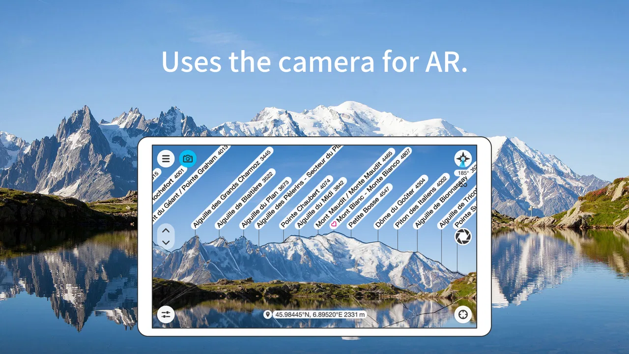
The central experience is a digital panorama panel that represents the mountain skyline around me. Rather than browsing a long directory of destinations, I use the screen as a visual reference. The appeal is strongest on a clear viewpoint, a balcony facing hills, a road overlook, or a trail where several ridges overlap and I want to understand the scene.
You May Also Like

 Blood Strike: 2.5 Anniversary
Blood Strike’s Loadouts Turn Every Drop Into a Tactical Gamble
A close look at Blood Strike’s custom loadouts: how fast access to signature weapons reshapes its battle royale rhythm, rewards preparation, and narrows the gap between fights.

 Pandora - Music & Podcasts
Pandora’s Music Is Easy to Start, but Harder to Recover
Pandora’s strength is its low-effort path from a seed to a station. Its weak spot is how much confidence it asks you to place in connection, setup, and quiet recovery.

 8 Ball Pool
 Is Built on Rivalries, Rematches, and Routine
A close look at the rivalries, rematches, shared routines, and unanswered safety questions that turn a quick pool match into a persistent mobile community.

 Samsung Music
’s Quiet Strength Is Playing What You Already Own
Its reach comes less from spectacle than from dependable access to a personal library. That simplicity is both the app’s strongest retention engine and its ceiling.

 AccuWeather: Weather Radar
AccuWeather Review: A Quick, Clear Forecast for Everyday Decisions
For everyday plans, the best forecast is the one you can understand quickly. AccuWeather makes rain timing, radar, and local conditions easy to act on, with a few trade-offs.

 Hill Climb Racing
Why Hill Climb Racing Still Turns Crashes Into One More Run
A tiny car, a bumpy hill and one more upgrade: Hill Climb Racing keeps resurfacing because its simple chaos makes every near-miss feel personal.
More From Our News Desk



I like this approach because it encourages looking up from the phone. The screen is not the destination; it is a labeled interpretation of what is already in front of me. When the outline matches the real terrain, the app gives a satisfying sense of orientation. It can also make a familiar view feel new by showing how many peaks sit behind the obvious foreground ridge.
The app has been available since March 17, 2011, and its current version is 4.8.74. That long presence matters to me because this is a focused tool rather than a new experiment built around a temporary trend. It has reached over 500 thousand installs and holds a 4.3 average from around 14 thousand ratings, which suggests that the basic idea has found a steady audience without needing to become a broad social platform.
The worldwide offline design is especially important for the way I would use it. Mountain viewpoints are exactly where mobile coverage can become unreliable, and I do not want the usefulness of a landscape tool to depend entirely on loading a live map at the summit. Offline access also makes the app calmer: I can prepare before leaving and use it later without waiting for a connection. Still, offline does not mean the phone loses every environmental limitation. A poor view, inaccurate orientation, or an obstructed horizon can still make the result less convincing.
That distinction is worth understanding before buying. PeakFinder is not a magic camera that recognizes every object in a photograph. I get the best results when I give it a sensible viewpoint and use the panorama as an aid to observation. If I expect automatic recognition from a casual snapshot taken through trees, I am likely to be disappointed. If I want a clean, offline skyline reference while standing at a viewpoint, the concept makes much more sense.
Who will get the most from it
I would recommend it to hikers, road trippers, landscape photographers, geography enthusiasts, and travelers who enjoy knowing the names behind a view. It is also useful for someone who visits the same overlook repeatedly and wants to learn the surrounding terrain gradually. Parents can use it as a simple way to turn a scenic stop into a small geography lesson, since the visual connection is easier to follow than a text-heavy list of peaks.
The app is less suitable for someone looking for turn-by-turn directions, trail difficulty, live weather, accommodation, or a complete trip planner. Those needs belong to other tools. I would also hesitate if I rarely visit mountainous places or if I mainly want a camera filter. The purchase becomes easier to justify when I expect to use the panorama repeatedly during trips rather than opening it once out of curiosity.
Getting started without making the first view frustrating
My advice is to install PeakFinder before the trip, not while standing at a remote viewpoint with a low battery and no signal. The app is designed to work offline worldwide, so the useful preparation is to open it in advance and become familiar with the panorama screen. I would also test it near home, even if the local landscape is modest. That first test is not about finding an impressive peak; it is about learning how the phone’s orientation affects the skyline.
On a first outing, I would stand somewhere with a broad, unobstructed view. A parking area or open meadow is usually a better learning environment than a narrow forest trail. I keep the phone level, point it toward the ridge, and compare the major shapes on the screen with the actual horizon. Starting with one obvious high point is easier than trying to interpret a complicated wall of overlapping hills.
The most important setup habit is calibration. Phones can be affected by nearby metal, vehicles, railings, or other sources of magnetic interference. If the panorama appears shifted, I do not immediately assume the mountain information is wrong. I move away from the interference, hold the phone steadily, and recalibrate according to the on-screen guidance. A few seconds spent correcting the direction can save a lot of confusion.
Location also deserves attention. A panorama depends on where I am standing, so a small difference can matter when ridges are close together or when I am looking across a valley. I make sure the app has an accurate starting position and avoid judging it while I am still moving. If I have just arrived by car, I wait until I am stationary before trying to match the skyline.
One practical advantage of preparing offline is that I can focus on the view instead of troubleshooting connectivity. I would not rely on a remote trip to be the first time I discover how the interface behaves. A short practice session helps me recognize whether the display is responding to movement, whether the direction is aligned, and how to return to a useful orientation after accidentally turning the phone.
The first meaningful success
My definition of success is not finding the name of every bump on the horizon. It is correctly matching one recognizable peak or ridge and then using that reference to understand the neighboring labels. Once one shape lines up, the rest of the panorama becomes much easier to read. This is a better first goal than scanning randomly because it gives me a visual anchor.
For a realistic everyday scenario, imagine arriving at a scenic stop during a drive. I have ten minutes before continuing, and the mountains look familiar but I cannot tell which summit is which. I open PeakFinder, let the viewpoint settle, face the largest ridge, and compare its outline with the screen. After identifying one prominent feature, I rotate slowly toward the adjacent peaks. Instead of merely taking another photograph, I leave with a clearer mental map of the view.
That workflow also works on a city break near hills. I might be standing on a terrace with a friend who asks what we are looking at. Rather than guessing from memory, I use the panorama as a conversation starter. The value is not only the label; it is the relationship between the peaks. I can see which summit is isolated, which ridge hides another, and why the skyline looks different from another side of the valley.
A useful tip is to take a moment to compare the silhouette, not just the text. Names can appear close together on a busy display, while the contour tells me whether the label belongs to the sharp peak, the shoulder behind it, or a lower point in front. I find that matching the shape first reduces the chance of confidently attaching the wrong name to the wrong mountain.
Another good habit is to use the app before the light changes dramatically. At dawn, dusk, fog, or heavy haze, the actual outline may be difficult to see even if the digital panorama remains clear. In those conditions, PeakFinder can still help me reason about the landscape, but I treat the result as an informed reference rather than a perfect visual confirmation.
Common confusion and how I work around it
The most common source of frustration is a mismatch between the phone’s heading and the real direction. When every label seems shifted, repeatedly tapping around is less useful than recalibrating and checking the position. I also avoid holding the phone close to a car roof, metal fence, or large backpack frame while testing the compass. These small environmental details can make a correct panorama look incorrect.
Another confusion comes from expecting the screen to behave like a live camera overlay. PeakFinder’s strength is the panorama representation, not necessarily a photograph with labels pasted directly onto every visible object. I read the display as a modeled skyline and then verify it against the terrain. That mental adjustment is important for first-time users because the app is most helpful when I interpret the graphic rather than waiting for an automatic camera-style recognition moment.
Overlapping mountains can also be misleading. A named summit may sit behind a closer ridge, so I might not see its full shape in reality. The panorama can show that relationship more clearly than my eyes, but it can also make the display feel busier. I zoom my attention onto the section I care about instead of trying to absorb the entire horizon at once. On a crowded mountain scene, one direction at a time is far more manageable.
Trees, buildings, haze, and cloud cover create another boundary. The app can provide a useful skyline reference, but it cannot remove a physical obstruction from the view. If I am in a forest clearing with only a narrow gap between branches, I use the visible section and avoid treating hidden peaks as visually confirmed. This is one reason I prefer an open viewpoint for the first session.
It is also easy to confuse a panorama tool with a navigation tool. PeakFinder can help me understand where a summit sits in relation to my viewpoint, but I would not use it alone to choose a route, estimate hiking safety, or judge current mountain conditions. A clear label does not tell me whether a trail is open, whether weather is changing, or whether the terrain is suitable for my ability. I pair it with dedicated maps and weather information when the outing involves more than sightseeing.
The offline capability has a similar trade-off. It is excellent for avoiding dependence on a live connection, but I still prepare the phone sensibly. I carry enough battery for the outing, avoid leaving the display active unnecessarily, and do not assume that offline access covers every other travel need. The app can remain available when a signal disappears; it does not turn the phone into a complete emergency device.
How it compares with familiar alternatives
Compared with a standard map app, PeakFinder is much quicker for answering the narrow question, “What am I looking at?” A map can show terrain, roads, and place names, but translating a top-down map into a distant skyline takes more effort. The panorama is more intuitive when I am standing still and looking outward.
Compared with a hiking app, it is also more specialized. Hiking services are better for route lines, distance planning, elevation profiles, and navigation decisions. PeakFinder wins when the route is already chosen and I want to understand the scenery along the way. I see it as a companion rather than a replacement, especially for a trip where I want both practical navigation and a richer sense of place.
Compared with a general travel guide, the app is less useful for deciding where to sleep, what to visit, or how to organize a day. Its advantage is immediacy at the viewpoint. I do not have to search through articles or image galleries and hope that a photograph was taken from the same direction. The trade-off is that it offers a narrower type of information and asks me to engage with the actual landscape.
Compared with a camera-based recognition app, I prefer PeakFinder when the goal is a whole skyline rather than a single object. A camera tool may feel more familiar to someone who wants instant recognition from an image, but a panorama gives me a broader spatial explanation. For me, that makes it better for learning a mountain range and weaker as a casual point-and-shoot identifier.
Going beyond the first peak
Once I understand the basic alignment, I use the app as a way to build a mental map. I start with the most recognizable summit, then follow the ridge left and right. This creates a sequence that I can remember after putting the phone away. The exercise is surprisingly useful for return visits because I begin noticing changes in light, snow, and visibility against a known outline.
I also use it before taking landscape photographs. Instead of choosing a viewpoint only because it looks attractive, I can explore which direction contains the most interesting arrangement of peaks. A sharp summit may be visually stronger when framed with a lower ridge, while a broad panorama may be better for showing the relationship between several valleys. The app does not replace my creative judgment, but it helps me decide what the landscape contains before I compose the shot.
For group travel, I find that one person can operate the phone while everyone else keeps watching the scenery. That sounds minor, but it prevents the usual problem where each person searches separately and the conversation turns into guesses. I point out one confirmed feature, pass along the phone briefly, and then return attention to the real view. The app works best as a shared reference, not as something everyone stares at continuously.
There is also a useful learning trade-off: the more I rely on labels, the less I may remember the landscape itself. I sometimes identify a peak, lock that information into memory, and then put the phone away. On a later visit, I try to recognize the silhouette before checking again. This turns the app from a permanent crutch into a tool for gradually improving my own sense of direction.
The purchase question becomes clearer after considering that workflow. At $5.99, it is not a free experiment, but it is also a straightforward one-time decision rather than a commitment I need to manage during every trip. I think the cost is reasonable for someone who regularly visits mountain regions and values offline access. For an occasional traveler whose destinations are mostly urban or flat, a free map or visual search tool may offer better value.
Android users should note that the app requires a minimum operating system version of 7.0. That makes it accessible on many older devices, although the quality of the experience still depends on the phone’s sensors, screen, battery condition, and ability to determine location accurately. I would check those practical basics before a long hike, especially if the device is several years old.
My recommendation after using it
PeakFinder succeeds because it does one thing clearly: it helps me connect mountain names with the skyline I can actually see. The offline worldwide approach gives it a strong advantage at remote viewpoints, while the visual panorama is more natural than trying to decode a conventional map. I especially like it for scenic stops, repeat visits, photography planning, and relaxed learning rather than urgent navigation.
Its limitations are equally clear. It depends on sensible positioning and orientation, and it cannot make a blocked or hazy view suddenly obvious. It is not a weather service, route planner, or safety system. New users may need a short calibration period, and people expecting automatic camera recognition may misunderstand what the panorama is designed to do.
My recommended path is simple: install it before traveling, practice in an open place, calibrate away from metal, identify one obvious ridge, and only then explore the rest of the skyline. That first successful match makes the interface feel reassuring instead of mysterious. After that, I would use it briefly at viewpoints and then put the phone away so the landscape remains the main experience.
With its Everyone age rating, established history, current version 4.8.74, and strong user response, PeakFinder feels like a dependable specialist rather than an all-purpose travel app. I would recommend it to anyone who has looked across a mountain valley and wished they knew what they were seeing. I would skip it only if mountain identification is not part of my trips or if I need detailed navigation more than visual orientation. For the right traveler, PeakFinder turns an anonymous horizon into a place I can understand and remember.
FAQs for PeakFinder
01What is PeakFinder and how does it work?
PeakFinder is an innovative app that allows users to identify mountain peaks and ranges by simply pointing their device at the landscape. Using augmented reality technology, it provides detailed information about over 850,000 peaks worldwide. The app functions offline, making it a reliable companion for hikers and outdoor enthusiasts.
02Does PeakFinder require an internet connection to function?
No, PeakFinder does not require an internet connection once it is installed and the relevant data is downloaded. This offline functionality is particularly useful for hikers and adventurers who might find themselves in remote areas with limited connectivity. Users will have access to peak information anywhere, anytime.
03Is PeakFinder available on both Android and iOS devices?
Yes, PeakFinder is available for both Android and iOS platforms. Users can download it from the Google Play Store or Apple App Store. The app is optimized for both operating systems, providing a seamless and intuitive user experience regardless of the device type.
04What are some of the key features of PeakFinder?
PeakFinder offers a range of features including augmented reality peak identification, a global database with over 850,000 peaks, offline capabilities, and the ability to view the landscape in 360 degrees. The app also provides sunrise and sunset times, enhancing its utility for outdoor adventures.
05Are there any costs associated with using PeakFinder?
PeakFinder is a paid app. Users must purchase it to download and access its full range of features. While there is a one-time fee, there are no recurring subscription costs, making it a cost-effective solution for those who frequently explore mountainous regions.
Pros
- Stunning 3D mountain renders.
- Offline functionality available.
- User-friendly interface.
- Regular updates with new peaks.
- Interactive landscape exploration.
Cons
- Limited free features.
- Occasional GPS inaccuracies.
- High battery consumption.
- No social sharing options.
- Requires initial learning curve.

PeakFinder
Gallery